Saturday, 7 September 2013

25. Day 17. Saturday 7th September 2013


I HAVE ARRIVED
AT THE EIGER APARTMENTS
IN WENGEN

After 16 days and 5 hours, I arrived in Wengen without using the train up from Lauterbrunnen! Having arrived in Lauterbrunnen just after 3pm (2 hours before I had planned) I decided I had to go for the full challenge ie: Door-to-Door. The cycle up was a lot more of "walking and pushing" than actually cycling, but I did it under my own steam. As I rounded the corner from under the railway past the Coop, I thought there might be a surprise reception party, but there was only me who knew what had just happened. Plus a couple of Americans who I asked to take my photo (above) and I had to explain why I needed the photo to contain me, the bike and the Eiger Residence.

Here's the last set of facts:
Start Point: Lyss 1490'
Highest Point during the day (and on the entire bike ride): 4180'
End Point: Wengen 4180'
Total climbing today 2935'
Today's climbing difficulty factor: 87
Distance travelled today: 65 miles
Cumulative distance since Alsager: 795 miles (finished)

The 795 miles took me 17 days. During the 17 days, I had 3 rest days and on 2 other days, I only did a very short day. So, a total of 12 plus 2 halves = 13 days. I spent 81 hours and 12 minutes actually cycling (ie: not counting having lunch or a rest) which works out at an average of 6 hours 15 minutes a day pedalling. And my average speed was 9.8 mph

The weather was very kind to me. The 81 hours and 12 mins break down as follows:
12 minutes raining
7 hours cloudy
74 hours sunny

Photos from the last day include Bern Bahnhof at 9.45 on a Saturday morning:


Followed about half an hour later by an interesting section of the route which followed the perimeter fence of Bern/Belp International Airport. It's not a vey big airport, and most of the major airlines (like BA) don't fly there because the runway is too short for today's typical passenger aircraft. However, I was surprised how close I was to the planes and what little security there seemed to be:


The route today was very pleasant basically west to east from Bern to Thun, along the south shore of Thunersee (Lake Thun) passed Spiez and onto Interlaken. I had driven this route in the car on a couple of occasions but today my bike route was along country lanes and forest trails running parallel to the busy road up to half a mile away.

This fast flowing river had some children in a canoe, a swimming pool beyond, and then I suddenly noticed a swimmer in the foreground. I'm not sure if he ever made it to the side because whilst I watched him, I would say he swam only 1m across the river for every 10m he was swept downstream.


Around the next corner, the clanking of bells on the Swiss cowherd typical of the Bernese Oberland region


A lot of my roads were probably the original roads that linked all the farms, as I did seem to be travelling from one farm to the next passing lots of crops, especially corn. As I neared one farm, I could see another cyclist ahead, but he seemed to be stopped. I approached from behind and turned back to look at him. I had a bit of a shock!


After 775 miles, maybe I felt like he looked!

Soon, I was in sight of Interlaken and familiar place names. The water in Lake Thun on my left was so clear I had to stop to take a photo:


And about an hour after this photo was taken, I had turned right away from Interlaken, through Wilderswil (which up until now, I had only thought of as a small train station, but is a very picturesque village), through Zweilutchinen, and on to Lauterbrunnen, where I arrived at ten past three.
Was "Option 3" a possibility? ie: not the extra night in a hotel; not the train up; but maybe I could literally achieve door-to-door.

I did a bit of mental arithmetic and worked out I needed to climb 5m every minute in order to be at the top for 5pm. My sat nav kept me up to date with my elevation, and with checks every 5 minutes to see if I was on plan, it gave me something to aim for. I stopped twice for liquid, which I had bought in Lauterbrunnen. One stop was at this cabin, which I am sure Bernard will recognise:


And at 4.55pm local time, I arrived. Wow, what a journey!
 
I would like to dedicate my bike ride to Ann, Ann's mum, and all friends and family who have been hurt by recent events.
 
I would like to thank a lot of people:

The fantastic guys at Halfords in Crewe who are brilliant at servicing my bike.
The volunteers who developed the website BikeRouteToaster.com which is essential in planning a long journey like this.
The Garmin sat nav which worked perfectly and got me out of the French Farmer's field
My Schwalbe Marathon tyres which are puncture resistant (with a metal strip running round the inside) and did 800 miles across everything from stony ground, to canal paths, thorns, and even the occasional broken glass.
Most of all, everyone who has encouraged me. First of all encouraging me to go on the journey at the outset. Offering to visit Ann, which made me much happier knowing she would not be alone whilst I was away. And, of course, all the encouragement during my trip. It really made a difference knowing people were reading my blog, and then the phone calls and the emails and the texts. Thank you. It made a big difference.

That's it. I hope you enjoyed following my bike ride.

Paul

Friday, 6 September 2013

24. Day 16. Friday 6th September

Start Point: La Coquerelle 2750'
Highest Point during the day (and on the entire bike ride): 3440'
End Point: Lyss 1490'
Total climbing today 1605'
Today's climbing difficulty factor: 70
Distance travelled today: 44 miles
Cumulative distance since Alsager: 730 miles

A lot of people think Switzerland is expensive, and it can be, but here is last night's splendid hotel in the Jura Mountains opposite a golf course. One night's bed and breakfast? £39.50


My bedroom was the one above the letters DE, and the sunshade over the tables is where I had two very cold beers at the end of my day's cycling! It was very sunny when I arrived. This photo was taken later in the day as the sun was setting.

By 9am, I was off again (too tired to repeat the 7.30 start on Thursday). I knew the highest part of the route was about 20 miles away, and after that, quite a lot of downhill. I had achieved 35-40 miles before lunch on some days, but I knew it would be an achievement today, if I reached the top and covered 20 miles before lunch. Within an hour, I had hit the steep bit, and stopped to take a breath at this sign warning about falling rocks!


Just after midday, I reached the top and took a photo of my sat nav. If you look carefully, you will see 703 miles done, and a current elevation of 1059m above sea level, approximately 3440 feet. I think this was the point when I knew I had done the Alsager to Wengen challenge. There wasn't much in front of me now that could go wrong. The bike had held out well and the final 80 or 90 miles were not going to stress it too much. And mentally and physically, I was also in good shape, so let's do it..


A few miles later, as I was descending at speed towards Les Reussilles, I heard this throaty engine behind me, just holding off ready for the overtake once the on coming traffic had passed. It was a Porsche, but not a modern one, more of a 'classic', followed by another, then another, then another. This was obviously an organised classic Porsche tour. I fumbled for my phone/camera but feared I was too late. Then I saw them all get held up at the T-junction a few hundred yards ahead. I got there just in time to snap this:


My friend Alan would have been 60 last month and he loved these cars.

In the afternoon, I started to think about overnight accommodation. I had been lucky on several occasions leaving it until the last minute, but I was starting to feel a little nervous. I had a look at the map and the route I was planned on, and realised I could get to Bern. However, all the hotels in this area were really expensive (it is the capital city) but I found one in Lyss, about an hour nearer that looked good quality and vfm with wifi. I was pretty tired at 3pm, so I decided to book it, and arrived about half past four. It was a good decision, as it's a nice hotel for half the price of Bern. With an underground secured car park where my bike is now situated. Before I left the UK, I put reflective tape on parts of the frame, and reflective spoke tubes. As it's turned out, I have done no cycling at night, but this photo shows I would definitely be seen in a car's headlights! The reflection here is from the camera flash.


After checking in, the first job was to buy some juice from the supermarket, and walking across to the small shopping centre, I snapped this for nostalgia (If you're over 40)


Still going strong in parts of Europe, but not in the UK.

So, finally, as usual, the map, and a big question..... Shall I go for the big finish tomorrow?

From here to Lauterbrunnen is about 60 miles, which is quite do-able. However, I had wondered when planning this challenge whether I could literally do door-to-door, and that would mean the last few miles would be walking from Lauterbrunnen to Wengen. It is so steep that it would be impossible to cycle up, but would probably take about 3 hours pushing the bike.

Option 1: Stay overnight again tomorrow and walk up Sunday morning.
Option 2: Get to Lauterbrunnen at 5pm after 60 miles of cycling and get the 14 minute train up, and save having to buy another hotel.

As I write this, I am thinking - option 2

Here's the map with only 60 miles between the blue and red dot     :-))


Thursday, 5 September 2013

23. Day 15. Thursday 5th September 2013

Start Point: Luxveuil les Bains 1005'
Highest point during the day: 2750'
End Point: La Caquerelle 2750'
Total climbing: 2300'
Climbing difficulty factor: 63
Distance: 70 miles
Cumulative distance: 686 miles

Probably the best day's cycling. Left Luxeuil early and had 50 miles done by 1.30 and crossed the Swiss border at 2pm. A bit disappointed not to find customs, passport control, or at least a big sign saying welcome to Switzerland!

The gradients started, and this photo taken about 3pm was to remind me how much I wanted to lie in this 2m long tub of cold water!


Instead, I took my helmet and gloves off, and more or less dipped my head in! The road ahead was just about do-able on the bike (as opposed to walking) but with an early start and 65 miles on the clock, I was ready for a stop if I saw anything.

The camera doesn't really capture the height, but this photo was taken at 2600' up the Jura Mountains and almost at the top of the first 'hump'.


About a mile further on, feeling like I might continue a little bit more, suddenly, there was a golf course on the left, and a hotel/restaurant on the right. Rooms available and bike storage! Back of the net!

Here is the elevation profile again (it looks slightly different as it's on the Garmin satnav rather than the computer, but you can see I'm over half way up.


You can just read the scale of 15 miles per square, so the summit is about 20 miles away. I'm confident I can do that tomorrow morning, and will be freewheeling down the other side towards Bern in the afternoon.

Wengen is only 63 miles away (as the crow flies) and about 110 on my route, so I'm starting to think I can do it without another rest day?

Here's the latest map. Me in blue. Wengen in red.

Wednesday, 4 September 2013

22. Day 14. Wednesday 4th September

No cycling today, but a quick post for you!
(You know, it is very encouraging receiving texts and emails from people following my ride. I also get a graph update each day showing how many "views" of the blog I've had.)

Today felt a bit frustrating, because I didn't feel exhausted and in need of the rest day. I felt like I wanted to get going. However, it was 30 degrees C and difficult walking round, never mind cycling.

I have a little kitchen in my room, so I went to the supermarket to buy breakfast. Did you know it's possible to spell out your home town with items on the shelf?


Later, I checked over the bike and the new tube and went into the town, but it was so uncomfortably hot, I retreated to my room, where I decided to try and "fix" the up/down route that lay ahead. As I said on an earlier post, it is quite disheartening to have worked hard to gain height to then lose it all on a big downhill freewheel.

My sat nav is made up of about eight 100 mile routes to get me from Alsager to Wengen. Where route 1 finishes, route 2 starts etc. I did it like this because when doing all the planning, I found occasionally a very long route might crash the computer before being saved. So I ended up doing it in chunks. Tomorrow, I have about 30 miles to go on my current route to get me to Belfort. At that point, I will load up my next section from Belfort to Bozingen.

It is this next section that was giving me concern. Here is what the elevation profile looked like:


As you can see, there is a pretty big range of hills/mountains between Belfort and Bozingen, and these can't really be avoided (maybe with a 300 mile detour!), so I have to accept that I need to climb from 300m to over 1000m (see the scale on the left) - this is from 1000 feet to 3300 feet, about the height of Snowdon. But, what I really don't want are the two massive dips on the way up.

I had planned the route at my desk at home a few months ago, and spent quite a bit of time trying to get it right, but there is nothing like being here - with a few aches and pains - to really focus you on trying again to improve it.

So here it is, the benefit of having a rest day, has created, after several trial and errors, a new route for my toughest bit. This is the new elevation profile:


The scale on the left is exactly the same, so it's still going from 1000 to 3300 feet, but almost in a straight climb. The distance on the bottom is actually a few kilometres shorter, down from 123km to 117km. So I have taken out the two big dips and shaved off 6km (about 4 miles)!

If all goes well tomorrow, I should finish my current section before lunch, then get started on the one above in the afternoon probably getting to the bit where it gets really steep by the end of the day. Coincidentally, the steep bit starts somewhere near the Swiss border.

My alarm is set for 6.45 as an early start should be nice and cool.

And finally, good news for those of you who thought 3 pairs of socks and 3 pairs of undies were not enough - they have all been washed, rinsed and dried whilst on my day off!


Tuesday, 3 September 2013

21. Day 13, Tues 3rd September 2013

Start Point: Bains-les-Bains 1020'
Highest point during the day: 1340'
End Point: Luxveuil les Bains 1005'
Total climbing: 490'
Climbing difficulty factor: 41
Distance: 23 miles
Cumulative distance: 616 miles

As mentioned last night, I looked at my options and took the decision to stay in Bains-les-Bains only one night instead of my planned two. I studied the route ahead and saw that within 25 miles I would reach what I hoped would be a much nicer spa town called Luxveuil les Bains, and when I found a reasonably priced nice hotel literally on my route, I made a booking for Tues/Weds nights.

This effectively means I have changed my "3 cycle/1 rest" to "3.5 cycle/1.5 rest". It's a bit extravagant having one and a half days off, but I think I am safely going to make it to Wengen within a week, so time-wise, I can afford to do it.

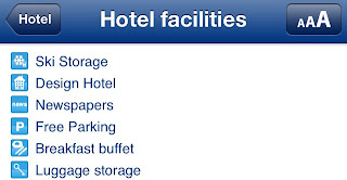
The hotel I booked was via the Booking.com website, where you can look at a list of the hotel's facilities. I knew I was getting nearer to the Alps, when top of their list was....................ski lockers!


I had noticed on Monday night that my front tyre was a little down on pressure, not much, but just enough to notice. I checked again this morning, and decided it needed topping up, especially as my pannier bags are on the front axle.

Unfortunately, when I removed the valve cap, I noticed that the screw-in part was badly bent (see photo)


As I tried to pump up the tyre, I was losing more air out of the tube, than I was putting air in. I had a spare tube with me, but didn't fancy changing it at 9am outside my hotel. I was keen to get going, and decided that if the loss of pressure was only slight over two weeks, then a couple of hours would be fine today to get me to Luxveuil, where I could sort everything out.

My plan worked as I arrived safely in Luxveuil about noon. The route there was very nice. Some minor roads and a forest trail (which was most welcome, as it was much cooler than the 28 degrees in the sun). Here is a photo I took on the move in the forest:


When I arrived at my destination (after only 23 miles :-) easy!), I was shown to a very clean underground garage where I could store my bike. The receptionist left the key with me to lock up, as I said I wanted to do some repairs. The more I tried to pump up the tyre, the more it went down. Eventually, I decided to remove the wheel, and took it up to my room.

I had brought a spare tube with me so it was 10 minutes to take out the old one and put in the new one. On removing the old tube, the valve broke in two so it was now no good anyway.

However, I had similar problems trying to inflate the new tube. I got it to about 70% full but it wasn't really going further. I wondered if my 'compact' pump might be faulty?

Once I had freshened up and got changed, I took the wheel with me and asked reception for the nearest bike shop which was about 10 minutes walk away. I bought a new tube and got the current one fully inflated (All for 3.5 Euros!). Unfortunately, the bike shop was really a motorbike shop that did a few pushbikes on the side, so when I looked at their bicycle pumps, they had only the large pumps you use standing up. I didn't fancy carrying one of those on my back for the rest of the ride! So, over the next couple of days I will have to find a proper bike shop and replace my 'compact' pump.

On my way back from the bike shop, I looked for a supermarket, as my bedroom has a small kitchen area, and I though I might eat in. Then again, why not order a takeaway? How about this advert I saw on a parked van? A one metre long pizza...


Maybe not!

So, here I am. Back in my room. The wheel is on the bike. The Oasis drink is in the fridge. The TV has an English speaking news channel. And I can rest for 36 hours.

I have done the map again, but I have zoomed in so that the Swiss border can be seen. My sat nav is telling me that, as the crow flies, it is only 111 miles to Wengen. But following my route and many hairpin bends, it's nearer to 180 miles. I think that should take me 4 or 5 days, so if I do 3 straight days on Thurs/Fri/Sat, then rest on Sunday, I should reach Wengen on Monday or Tuesday next week. Fingers crossed!

Monday, 2 September 2013

20. Day 12. 2nd September 2013

Start Point: Ludres 890'
Highest Point during the day: 1330'
End Point: Bains-les-Bains 1020'
Total Climbing 1220'
Climbing difficulty factor 38
Distance: 62 miles
Cumulative distance: 593 miles

Can anybody help me with French? I took this photo where I stopped for a break this morning. I would look it up on the internet but have to keep running to the loo:


 No, I didn't drink it, although it was very cold and tempting.

Breakfast was a supermarche stop at 9.30 consisting of crepes and the drink whose name I use when book a hotel. (It works fine if you say "Lipton - comme le the"


The morning was a slower than usual start. A combination of third day energy levels down, and a few texts and emails to sort out. I had a few 15 minute stops and had only 31 miles done by 1 o'clock instead of my targeted 40.

Most of today's route was on minor roads following the Moselle river south. By lunchtime I was at Epinal and stopped to see how Jennee got on in her interview for a new job. By the time I got to my destination of Bains-les-Bains, she had been offered the job. Well done Jen!

I'm supposed to be having my rest day tomorrow, but I'm not sure I want to spend a day wandering round this place. I've spent half an hour tonight doing that and it's a bit dead. It looks like a town that once did well with tourism - there are some springs here, hence the name - but it's seen better days and a lot of hotels and shops are closed. I'm wondering whether to do a short day tomorrow (20 miles or so) then have Wednesday as my day off. I'll have a look at the map and weigh things up.

I seem to be ahead of plan - about 200 miles to Wengen with a flight home booked in 11 days. So should be able to be a bit flexible. Here is the latest map:

Sunday, 1 September 2013

19. Day 11. 1st September 2013

Start Point: Verdun 1185'
Highest Point during the day: 1185'
End Point: Ludres 890'
Total Climbing 1660'
Climbing difficulty factor 43
Distance: 74 miles
Cumulative distance: 531 miles

Cycling is a lot like skiing - but without the chairlifts!
I thought that this morning as I was speeding down a half mile long road with sweeping bends and good views all around. But the difference at the bottom is you have lost all that potential energy and you have to work very hard to regain it. It almost gets to the point that you feel dismayed when you see the route ahead is downhill. You don't want to lose the height you've worked so hard to attain.

Last night I went out for a meal in Verdun. There was a lot to choose from, as my F1 hotel was in a commercial area with many retailers, the French equivalent of B&Q, KFC etc. Amongst the big retailers was Decathlon who sell sports goods, so a new bottle holder was purchased for 4 Euros:


Something else I spotted on my evening walk, was a coin operated car wash station, so before any proper cycling commenced on Sunday, I was at the car wash at 8.45 for a "lavage et rinse"
Here's my bike looking as good as new again:


The day was pleasant. A little cold at first. No breakfast taken at the hotel so during the first hour kept my eyes open for food. The supermarkets were of course closed on Sunday in France, but one village had a nice boulangerie with a queue to the door. Either it was very good or the only one around. After the two pain au chocolat, I would say it was good. As the sun started to take effect, the jacket came off at 11 and by 1pm I had 35 miles on the clock and time for another break.

Soon after that, a big milestone was achieved:


Yes, 500 miles since leaving Alsager, and a feeling now that I can definitely do this! Here's the map, blue dot me, red Wengen